
Article written by

Flood risk management: European framework and SOCOTEC services
Mon 05/10/2026 - 15:15
September and October require enhanced surveillance of assets located in flood zones
Every year, with the arrival of September, the Mediterranean becomes the scene of a meteorological phenomenon that is already part of the daily vocabulary: the DANA (Isolated Depression at High Levels). These masses of cold air that are disconnected from the general atmospheric circulation cause, when they come into contact with the warm and humid air of the Mediterranean, episodes of torrential rains capable of generating sudden floods, overflowing rivers and wadis, and material and human damage of great magnitude.
It is no coincidence that September and October historically concentrate the most intense DANA episodes in the Iberian Peninsula. The combination of surface sea waters that are still very warm after the summer and the first influxes of cold air at altitude creates the perfect breeding ground for these extreme phenomena. For this reason, this time of year requires reinforced surveillance of infrastructures, buildings and economic assets located in potentially vulnerable areas.


At the European level, floods and droughts account for approximately 90% of the total losses covered by insurance and solidarity mechanisms. Between 2001 and 2021, there were, on average, about four serious natural events per year in Europe – "serious" being understood as one that causes between 10 and 99 fatalities or between 30 and 3,300 million euros in material damage – and two out of three of these events corresponded to floods.
EUROPEAN LEGISLATIVE FRAMEWORK
Three complementary instruments

European risk management policy is structured around three regulatory pillars:
- Water Framework Directive (2000/60/EC): a cornerstone of European water policy, aimed at achieving good ecological and chemical status of rivers, lakes, transitional waters, coastal and groundwater.
- EU Floods Directive (2007/60/EC): a specific pillar of flood risk management, focusing on protecting human health, the environment, infrastructure and economic activity.
- EU Climate Adaptation Strategy: introduces the concept of climate-proofing, requiring long-term risk assessments and infrastructure design to incorporate future climate projections (more frequent extreme events, heavier rainfall, sea level rise).
European risk management policy is structured around three regulatory pillars:
- Water Framework Directive (2000/60/EC): a cornerstone of European water policy, aimed at achieving good ecological and chemical status of rivers, lakes, transitional waters, coastal and groundwater.
- EU Floods Directive (2007/60/EC): a specific pillar of flood risk management, focusing on protecting human health, the environment, infrastructure and economic activity.
- EU Climate Adaptation Strategy: introduces the concept of climate-proofing, requiring long-term risk assessments and infrastructure design to incorporate future climate projections (more frequent extreme events, heavier rainfall, sea level rise).
Flood Risk Management Cycle
These directives are deployed through a four-stage flood risk management cycle:
- PFRA (Preliminary Flood Risk Assessment): preliminary assessment on a macro scale, based on historical data and characteristics of the basins.
- Identification of APSFR (Areas of Potential Significant Flood Risk): delimitation of rivers, basins, sub-basins and priority coastal areas.
- Hazard and risk maps: representation of the potential extent of water, depth, flow velocity and impacts on population, economic assets, protected areas and industrial facilities, for different return periods.
- Flood Risk Management Plans (FRMPs): plans that coordinate prevention, protection and preparedness, and that mark the roadmap for public investments and technical studies.
- At the operational level, tools such as the EU Flood Risk Area Viewer (European Commission / European Environment Agency) and the European Flood Awareness System (EFAS) make it possible to visualise risk areas and generate flood forecasts in real time, up to 10 days in advance, with free access.
Flood risk assessment and management actions
On this regulatory basis, flood risk studies deploy a set of technical analyses that allow us to move from a generic risk assessment to a precise characterisation of each site:
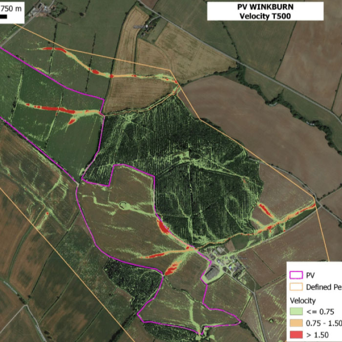
This type of technical and regulatory support is particularly relevant for developers, asset owners and operators managing buildings in areas historically regulated against flooding, as well as for new projects located near rivers or in potentially exposed areas, where local regulations may require specific vulnerability assessments as a requirement for the building permit.
The European regulatory framework – the Water Framework Directive, the Floods Directive and the Climate Adaptation Strategy – will continue to require increasingly rigorous flood risk assessments for new and existing projects. The combination of flood risk studies, hydraulic modelling and mitigation engineering is now the technical reference standard for anticipating this risk before it materialises.
Do you need to assess the exposure to flood risk of your facilities or projects?
Our water risk management experts can carry out the technical diagnosis and define the most appropriate mitigation measures for your case.
You might also be interested...


Get the latest updates about SOCOTEC, subscribe to our newsletter !