
Mobile Mapping
Advanced technology for mass geospatial data capture
We transform the collection of urban and road information with mobile mapping technology, generating accurate 3D models, 360° panoramas, detailed point clouds and digital twins for infrastructure and city projects.
Mobile Mapping is revolutionizing territorial data capture, allowing large linear extensions to be documented quickly, safely and accurately. Our mobile mapping service captures massive data in a single pass to deliver high-quality georeferenced information through digitized GPS inspections, crucial to ensure fully profitable and achievable projects.
At SOCOTEC we have technicians who are experts in the use of instrumented vehicles that move in situ to collect visual and geometric data continuously, allowing a comprehensive digitized geospatial analysis.
Mobile Mapping Applications
Each application is designed to provide highly accurate data that is transformed into valuable decision-making insights. Whether it's generating complete urban inventories, conducting road condition audits, developing urban digital twins, or implementing infrastructure asset management systems, our Mobile Mapping is tailored to the specific needs of each project, ensuring reliable and actionable results.

Talk to our experts


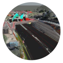
Point Clouds and 3D Survey of Public Roads
Point cloud surveys are captured using vehicle-mounted LiDAR sensors to collect large amounts of detailed information quickly and accurately over extensive routes. This information is used to generate 3D surveys of public roads and digital models of the urban environment, roads or infrastructures analysed, containing detail points of all the structures in a continuous and georeferenced view.

360° panoramas
Our Mobile Mapping systems are equipped with high-definition panoramic cameras that capture 360-degree images of each point of the route. These images create a permanent record of the state of streets, facades, signage and street furniture, and can be used for remote consultation, measurements and generation of immersive virtual tours.
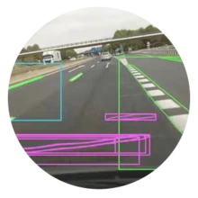
Inventories and Analytics with AI
The information captured is used to carry out the inventory of street furniture using Mobile Mapping in an automated way: vertical and horizontal signage, public lighting, traffic lights, manholes, scuppers, trees and street furniture. With the support of artificial intelligence, the automatic detection of urban damage is implemented and structured GIS layers are generated. In addition, analysis of the state of the pavement, thematic cartography and support for predictive maintenance planning of urban infrastructures can be obtained.
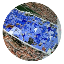
Digital Twins
The urban digital twin integrates geometry, panoramic image, inventory and spatial data in a single searchable base. It allows you to know the updated status of streets, infrastructures, municipal assets and facilitates planning, maintenance, mobility and support for strategic decisions through Infrastructure Asset Management. It is a transversal tool for daily operation and long-term planning.
Benefits of Mobile Mapping
- Massive and fast capture of large linear distances with state-of-the-art technology
- Data supplied in multiple formats: 360° panoramas, LiDAR point clouds, and GIS databases
- Digitized GPS inspections with precise georeferencing using high-precision GNSS/IMU systems
- Reduction of campaign times and multiplication of coverage compared to specific methodologies
- Greater safety by minimizing the presence of personnel on roads
- Integration with BIM and GIS software for visualization, analysis, and management of infrastructure assets
- Inventory of street furniture through automated Mobile Mapping using applied artificial intelligence
- Web consultation platforms for measurement, analysis and reporting
- Road condition audit and urban conservation status mapping
- Automated pavement and signage inspection for predictive maintenance
Advanced Analytics and Mapping of the State of Urban Conservation
The analytical exploitation of data allows us to obtain key indicators for infrastructure asset management and decision-making:

INVENTORY AND ANALYTICS
The highest value of Mobile Mapping that saves time and effort to gain security

The information captured is used to inventory signage, lighting, road markings, covers, scuppers, trees and street furniture through an inventory of street furniture using Mobile Mapping.
With the support of AI, the automatic detection of urban defects is automated and structured GIS layers are generated for infrastructure asset management.
In addition, pavement condition analyses can be obtained through mobile pavement inspection, thematic mapping and support for predictive maintenance planning of urban infrastructures.
The result is an updatable digital base for municipal management and operation of urban services:
- Public spaces
- Gardens
- Vertical Signs
- Traffic lights
- Manholes
- Horizontal Signs

Comprehensive digitalisation of urban road networks
Complete capture of streets, avenues and public spaces for municipal inventory, management of infrastructure assets, audit of the state of public roads and urban planning using urban digital twins.

Roads and infrastructure corridors
Continuous survey of road layouts, geometric control, inspection of mobile pavement, monitoring of the condition of the pavement and as-built documentation of linear works.

Municipal asset management
Inventario de mobiliario urbano mediante Mobile Mapping y localización de señalización, alumbrado, mobiliario, vegetación y elementos de drenaje para optimizar la operación de servicios urbanos mediante mantenimiento predictivo de infraestructuras urbanas.
TRUST&TECH
Technology at the service of sustainability and trust

In an increasingly demanding environment, digital transformation and technical credibility are critical. At SOCOTEC, we develop a proprietary approach we call Trust & Tech: a strategy that combines technological innovation with the critical role we play as a trusted independent third party.
Through advanced tools such as BIM, digital twins, CFD simulation, remote instrumentation or proprietary data analysis platforms, we improve the quality, traceability and efficiency of our services. This technological layer allows:
- Accurately audit complex assets and extend their lifecycle.
- Detect opportunities for decarbonisation, energy efficiency and circularity with predictive models.
- Ensure regulatory compliance through traceable and secure digital flows.
- To offer an objective and transparent assessment that reinforces trust between customers, investors and regulators.
Trust & Tech is also an ethical and structural response to today's challenges. As an entity with more than 250 official accreditations and aligned with frameworks such as the European Taxonomy and the Green Deal, we provide technical guarantees that transform sustainability into real and measurable value.
Boost your project with Mobile Mapping
Do you need to capture accurate geospatial data for your urban infrastructure? Our Mobile Mapping experts are ready to help you digitize your assets, optimize infrastructure management, and make decisions based on highly accurate data.
Frequently Asked Questions about Mobile Mapping
